Thursday, December 23, 2010

SNP 12-23-10

Last week I decided that I was going hiking today!  It had been a really long time since I’d gotten out and it was the 1st thing I wanted to do over winter break! I was really excited when I realized it was a Thursday, in December no less, so I figured I’d be able to get a parking place at any trailhead I wanted! (so often I go out there on weekends and there’s no parking where I want to hike!). 

I was thinking I’d park at Meadow Springs and hike up to Mary’s Rock – a great viewpoint.  Well, my plan was foiled by the fact that Skyline Drive was closed.  That severely limited my hiking options.  I could still get to Mary’s Rock, but I’d have to go up the AT and it was potentially very icy.   Another option was to hike part of the Dickey Ridge Trail up in Front Royal.  Going to Thorton Gap would give me more options if one trail was too icy.  

I headed out this morning, arriving in Thorton Gap, the spot that was formerly known as Panorama, at about 11 am.  When I pulled into the parking area there were 2 other cars – I saw the occupant of one of them as he was heading out.  I expected to see him again, but he must have gone north on the AT because I never saw him again and the car was gone when I got back!   Just before I got out of the car a HUGE gust of wind blew up and shook the whole car!  yikes.  I hadn’t considered wind.  If it was this windy down here, it was going to be extra windy at the summit which was 1,000 ft higher than I already was!

I donned all my layers and headed out!  It was more than a bit brisk.  And the wind was whipping something fierce.   Once I got into the woods the trees blocked most of the wind, but it was still very loud!  It was a sustained wind at about 20-30 MPH, with gusts topping 50 MPH (when I got home I discovered that the area was under a wind advisory!).  The trail was in good shape! There was a dusting of snow, but there was no ice!

As I began to climb I started to get hot.  Temps in the 20s with a 50 mph wind and I was hot.  Go figure.  Just goes to show that with the right gear there’s no such thing as bad conditions!

The trail wound around the mountain and soon there was no wind because the mountain was blocking it!  YAY! It was a steady climb, but not hard and not very steep.  I’d hiked this trail once before in 2001 and I remembered it being very steep and narrow.  Today I didn’t notice any of those things – the trail felt very wide! Must have been my newbie hiker viewpoint!  It might have seemed narrow before I climbed the 90 degree rock face hand over hand to get to the top of Penobscot Mt in Acadia!

I was happily hiking along enjoying the views, probably 3/4 of the way to the top, when I came to a HUGE stretch of solid ice.  The trail was completely obscured by a solid sheet ice.  hmmmm… There was a way around it, I could bushwhack a bit up the hill by the side of the trail and get around it, but I was worried about getting back, I was also concerned with what else I would encounter as I got closer to the summit.  I’d considered doing a loop using Skyline Drive as my return route, but that was looking pretty unappealing since Skyline Drive was cleared of snow, just a road walk.  Even if I’d decided to do a loop, there was still the possibility I’d encounter more impassable ice and have to come back over this section. 

So, deciding to err on the side of caution I turned around and headed back to Thorton Gap.  My plan was to eat my sandwich in the protection of my car and then head down to Buck Hollow to hike some more! 

On the way down I saw some burned out trees from the big fire of 2000.  That was the 1st year I was here and I was actually in the park the day it was burning! I’d been hiking near the Dickey Ridge Visitor Center and decided to drive to Thorton Gap and exit there.  I knew there was a big fire and that the Central District of the park was closed, but I hadn’t expected to see the fire!  The sun had just set as I was driving into Thorton Gap and it was pretty dark and the side of Mary’s Rock Mt was glowing red with flames!  It was a pretty amazing sight! The rest of the hike back down was quick and easy and soon I was back at the car!

I quickly ate my sandwich, responded to a text I’d gotten (3G service at Thorton Gap is a blessing and a curse!), and then headed down the mountain to Buck Hollow. 

Buck Ridge – Buck Hollow is an excellent hike that you can get to from the park boundary.  It’s about 5 miles round trip – up to Skyline Drive and back.  I hiked it a few years back with Daisy Mae! I’d considered hiking the whole loop today, but I’d read a trail report from a week or so ago and it said Buck Hollow (the return, downhill, trail) was icy in places, so I was  hesitant to attempt the loop.  I thought that the Buck Hollow trail went along a stream, so I decided I’d hike up that trail until I either ran out of time, or encountered too much ice. 

I was the 4th car in the parking area, so I was anticipating seeing some other hikers.

The trail starts with 2 stream crossings.  One that I wasn’t a huge fan of as the rocks were uneven and it was a little scary, but I made it over (and back later!).  The other crossings were very easy thanks to the hard work of the PATC I’m sure! This trail started much lower on the mountain (although it’s the same mountain I had been hiking on earlier!), so there was less snow at 1st but as the trail gradually climbed there was more snow and more ice!

It was a lovely quiet walk.  The wind was high in the trees and not bothering me way down in the valley! The sun was peeking over the mountain making it very warm (yep, I was hot again!). 

I’d been hiking about an hour when I ran into the only people I’d see on the trail that day – a couple who told me that they’d just gotten engaged! He’d drug her into the woods and popped the question and I was the 1st know!  His timing was pretty good – I encountered them only a few feet from where he proposed, I’m glad I didn’t walk up on “the act”.  What is trail etiquette for walking to engagements in action?   I congratulated them and offered to take their picture which they thought was a great idea!  They posed and I snapped a shot with his iPhone look-alike phone and headed on up the trail. 

Soon I came to a section of the trail was all iced up! It was easy to get around as the terrain is very flat and I could just go off trail a bit.  Then I quickly came to another stream crossing.  This one had some patchy ice on some of the rocks.  I knew I could make it across, but I wasn’t sure about getting back, so I decided to call it a day and turn around.  It was 2:00, only 30 minutes shy of my “turn around time”.   I wasn’t done hiking yet though, so I walked back as slow as I could!  By this time the sun had sunk below the mountain and it was getting chilly!

When I got back to the car the parking area was deserted! I knew that one of the cars had been the newly engaged couple and I guess the other 2 people had hiked down Buck Ridge (which is VERY steep – it’s better to go up that way so I was surprised!) and that’s why I hadn’t seen them. 

I drove back up the mountain to use the facilities at Thorton Gap before heading home.  The Pass Mountain Trail parking area on 211 was also empty (there had been 2 cars earlier), as was the Thorton Gap parking area.  It was only 3 pm, but I guess the cold and wind had driven everyone away early!

Since Skyline Drive was closed I had no choice but to just drive home! I was amazed that I made it home before dark!


SNP 12-23-10

Sunday, October 31, 2010

Rally to Restore Sanity

Yesterday was Jon Stewart and Steven Colbert’s “Rally to Restore Sanity and/or Fear”.  I’m not big on politics at all, and until about a week ago I’d never watched The Daily Show and never even heard of Steven Colbert.  But this looked like a rally I could get into.  It’s wasn’t about subscribing to a certain political viewpoint, but rather about big ideas we should all be embracing. Ideas like being reasonable and listening and disagreeing appropriately.  And most importantly: Don’t be douchey. 

This CNN article about the rally really hits the nail on the head about what it was all about:

http://www.cnn.com/2010/OPINION/10/31/avlon.rally.sanity/

In the 10 years that I have lived here in the DC area, I have been into DC for 2 major events – this rally and the National Book Festival a year ago.  So I was excited even to just be a part of something this big and exciting!  And big it definitely was!  An estimated 215,000 people were there.  They are saying it was the biggest event in DC since President Obama’s Inauguration!

We managed to have a near perfect experience with the whole thing!  We couldn’t have done better if we’d planned it!

Andy and I met at the Woodbridge Commuter lot a little after 8 and headed up to the Springfield Metro.  There was a short line of cars getting into the parking garage but after we got in there were TONS of spots!  We got a spot right by the stairs and walked into the station and right onto a train!  The one bit of pre-planning we did – me going to the metro station a few days early and securing fare cards for both of us – really paid off as there was a line of people waiting to get their fare cards.  It was nothing like it would be later in the day – people waited over an hour just to get their fare cards! 

It’s another story for another time (it’s a great story that makes me very happy, but has nothing do with the rally!) but I had a pink flamingo hat from my Halloween costume and I decided that it would be fun to wear the hat at the rally.  The flamingo had no real significance whatsoever, but it was fun! Random flamingos are always funny! As we got on the metro the people behind us remarked about the flamingo!  It was one of the ladies’ favorite animal!  She even took my picture to send to her daughter!  We started chatting and had a few good laughs!  I wore the flamingo hat for the pre-show but when we sang the national anthem I took it off and then realized how hot it was! 

We arrived at L’Enfant Metro station at 9:20 and waited about 30 minutes for Keith and Virginia to arrive from Vienna.  There was a steady stream of people headed to the rally but it wasn’t that busy yet.  We walked up the street and right onto the mall and into the rally area.   We quickly found a good spot, right in front of one of the big jumbotrons! We were between the National Gallery and the Air & Space Museum, closer to the museum. We had a view of the actual stage, but we couldn’t see what was going on. 

Right after we got there we all pulled out our phones to check in on Foursquare or Facebook.   There were so many people there that the cellular networks were overloaded and not working!  I finally was able to check in on Foursquare through the Official Rally App using the free public Wifi.  When I checked in I unlocked 5 new badges, including the “Epic Swarm” badge – that’s when more than 1,000 Foursquare users check in at the same place!

We settled in and watched all the people who were streaming into the rally area.  There were some awesome signs!  Everyone was encouraged to bring a sign and there was a wide range of signs from the silly to serious.  Some were political, others were just goofy, others just had good ideas!  I took pictures of the ones I saw that I liked, and there are a bunch of others here:

http://www.buzzfeed.com/mjs538/the-100-best-signs-at-the-rally-to-restore-sanity

Right before the actual rally began the Mythbusters did a pre-rally show.  We did the wave and all jumped simultaneously to see if it would show up on the seismograph and we did the 200,000 person “cheek pop”.   They showed live views of the crowd on the jumbotrons – there were packed people from the Capitol building to the Washington Monument! We could see the steps of National Gallery and they were PACKED with people!  So many people every where!

The actual rally was almost a parody of other rallies!  There were poems, a benedictions, awards, musical performances, and celebrity guests, all kinda silly, but still getting to the point that what’s really silly is how crazy politics and Americans in general have gotten. 

When the rally ended we’d planned to just stay put for 20-30 minutes to let people clear out but somehow we didn’t.  We packed up and started heading toward the American Indian Museum.  We’d naively thought that there wouldn’t be anyone there.  HA!  Since we’d gotten there so early and so painlessly and then hadn’t moved, we really had no concept of just how many people were packed into the National Mall area!  The streets and sidewalks were packed!  We could barely walk! The flamingo hat came in very handy!  I lead the way and everyone followed me!  We were holding on to each other clothing and bags, but still the flamingo hat made it easy to stay together!  We headed over to the museum anyway in hopes of getting some food and finding a bathroom that didn’t have someone sitting on it! (yes people had climbed on top of the porta potties to get a view of the stage!) Our hopes were quickly dashed when we saw the line to get in!  So much for that! 

None of our phones were working, even the free public wifi on the Mall wasn’t working.  So we struck out in hopes of finding something!  We headed down 3rd away from the mall and very soon the crowd thinned out, however, there was really nothing down there. We finally got one of our iPhones to work and found a McDonald’s nearby and headed to it.  By this point we were all getting a little cranky and tired so it got a little tense.   We finally got to the McDonalds and after waiting in line for 10 minutes to finally use the bathroom with the extremely sticky floor and only one functioning toilet, and water so scalding hot you couldn’t get your hands under it(I really should have just taken my chances hiding in the bushes in front of the Health and Human Services Department building!) I felt a lot better!

We went back and forth on what to do next – we didn’t really want to try and get back on the metro, but there weren’t many options for places to hang out.  Finally we decided to accept my friends Matthew & Michael’s invitation to come over to Michael’s place on Capitol Hill to hang for awhile.  Keith and Virginia weren’t up to walking all the way over there and really wanted food so we decided to part ways. 

Andy and I headed back toward the Mall – there were still people hanging around, but for the most part the crowed had all headed out.  We got a little lost – thank you Google Maps for 1) not loading (the cellular service was still a bit wonky) and 2) when you did load you lead us the wrong way! We finally used the “phone app” on our pocket computers and Matthew helped us find the place!

It was awesome to hang with Michael & Matthew and their friends for a little while!  They had the 3 things we needed most – a plug for Andy’s phone, a place to sit, and water! (Not having any access to a bathroom all day lead all of us to avoid drinking and we were a bit dehydrated!).  We hung out there until about 6:30 and then headed back to the metro. 

The closest metro station was Union Station so we walked the 5 or 6 blocks over there and got on a red line train.  We had to switch to a blue train at Metro Center and when we arrived at Metro Center the train we were on was PACKED!  We were trying to get off and everyone was pushing and shoving.  There was a man in wheelchair who’d gotten on at Union Station with us.  He was with 4 other people and I’d noticed they were all talking in sign language.  When we arrived at Metro Center the man in the wheelchair and his friends were trying to get off the train, but there were soooo many people they couldn’t get off.  And, because they were deaf they couldn’t yell “move it” or ask people to move.  Like a moron I asked one of the friends if they were trying to get off?  Then I got smart and motioned to the door and the gal nodded that “yes” they were getting off. So I said “Hey, can you all let this guy through” and promptly everyone near the door parted ways for the man in the wheelchair to get out.  The only problem was the people in the back didn’t see and they started yelling and pushing.  We all yelled back “chill out, we’ve got a wheelchair here!” They mostly stopped but there was still a crush of people getting off!  I finally got spewed out on the platform and stepped back to wait for Andy.  He was one of the last to get off the train and he later told me that the door closed on his leg!  He said he pulled out pretty quick, and that the door opened again right after he pulled it out!

Considering that was our only real metro issue on a day when there were 215,000 people in DC for a rally, I say it was awesome!

We finally made it back to Springfield a little after 8:00 and drug ourselves to Andy’s car! Our legs were not willing to carry us even a foot further!

It was a great day!  Fun rally!  Great ideas to think about! Fun times with good friends! :-) 


See Virginia's Rally pictures here:
http://picasaweb.google.com/vleveland/RallyToRestoreSanityAndorFearOct302010#

Wednesday, August 25, 2010

My Alpaca Scarf

When we were in Washington we took a day trip out to the San Juan Islands.  We only had time to check out one of the many islands so we went to San Juan – the most developed of the islands.  There was lots to see and do in Friday Harbor and the rest of the island and in just a few hours we were able to check out most of it, even if it was at a Speedy Gonzalez speed!

One of our stops was at the Krystal Acres Alpaca Farm. When we got there our first stop was to check out the cute and cuddly alpacas that were grazing in their pens.

P1090319   P1090322

They would come to the fence, but if you tried to pet them, they’d walk away.  They were very entertaining though! 

After a little bonding with the animals we went to check out the gift shop! 

They had some beautiful hand knit sweaters, socks, and scarves as well as stuffed animals.  I found a pair of socks that I really liked and as I was admiring them I struck up a coversation with the gal who was working there.  Turns out, she not only hand knit the socks from the “wool” (not sure if it’s called wool or just fiber) from the alpacas we’d just met, but she hand dyed the fibers as well!  I was pretty sold and was about to buy the socks, until I saw the price tag!  $60.  For socks.  I get why they were so much, but I just couldn’t do it. 

I was ecstatic when I saw that they had yarn for sale.  Hand dyed no less, by the woman I’d been talking to! As I was admiring the yarn the saleslady showed me the crochet patterns that she had created.  There was a simple scarf pattern that used exactly one skein of the yarn! It looked easy enough that I would be able to figure it out (I have never crocheted from a pattern)  I was sold!  

The only challenge was picking the 1 skein of yarn that I liked best! Naturally I picked purple!

When I got home it was time to start working on my do-it yourself souvenir. 

P1090541 

All my supplies, ready to begin!  I did have to go purchase a crochet hook in the proper size – I was surprised how dainty it was, I’d expected it to be a bulky scarf, but in the end the yarn was very thin. 

P1090542

Before I began working on the real thing I did a practice swatch to make sure I was reading the pattern correctly and that I understood what I needed to do.  I did this before I got the new hook with some leftover cotton yarn so it’s much bulkier than the scarf was. 

The only stitches involved in the scarf were single crochets and chains!

As I worked keeping the yarn from getting tangled became an increasing problem!  As you can see in the picture above the yarn came all wound around itself and as soon I started pulling strands it started getting tangled.  I decided it would help if I hung the yarn up so I stuck it on the sliding glass door handle:

P1090543

The yarn kept getting stuck on the edges of the door handle.  No good.

So I decided to hammer a nail into the wall and hang the yarn on it:

P1090544

This was actually worse because the other end of the yarn started getting tangled.  Eventually it was so hopelessly tangled I had no choice but to stop crocheting and starting with the loose end of the yarn, wind it into a ball.  This was a slow and tedious process because the yarn is very fine and all the same color and the knots were tight.  As a further complication the more tangled it got the more it started to fuzz up and there were lots of little (and not so little) fuzzies compounding my untangling! Finally I got it all rolled up into a nice ball and I was ready to keep going.

P1090545

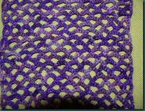
Here’s a close up of the detail:

P1090547The rest of the scarf continued until I ran out of yarn!  I managed to get it exactly right as I was left with about 8 inches of yarn when I was done and I didn’t have to rip anything out because I ran out of yarn before I’d finished it! 

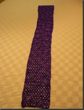
Here’s the finished scarf:

P1090591 I really like it! It’s very soft!  I’m also really excited that I made it myself, following the pattern and it came out right!  It’s a little short and a lot daintier than I’d expected so I’m not really sure when I’ll wear it, but it was lots of fun to make! :-)

Saturday, July 31, 2010

Seattle

Today was the day to return my RV and make my final preparations for heading home. 

I was up early to shower and finish up my RV chores – pack, clean, dump, fill with water, etc.  I left the campground at 8 and headed back to Everett, an hour away!  Once in Everett I got propane to replace what I’d used and filled up with gas before returning to Cruise America.  My check-in went flawlessly and soon we were on our way to Seattle!

The plan was to hit the two biggest Seattle tourist attractions: Pike Place Market and The Space Needle.  We were heading to the Needle 1st, but it was cloudy so we decided to go to Pike Place.  Took a bit of navigating – with 1 iPhone, 1 Driod, 1 Jeep Navigation System, and 1 paper map – to find parking, but once we did we headed up to the market. 

What a cool place! The flowers and fresh fruit and veggies were so pretty! There was fish and meat all on display too!  I could spend all day exploring all the other little shops!

After we wandered through the market we went to Etta’s for lunch!  Mom and Dad had eaten at Etta’s when they were in Seattle 10 years ago and have raved about it ever since.  Salmon is their specialty, and it was really good! :-)

After lunch it was still cloudy, but the weather channel said it was going to be sunny later and the sun was trying to break though the clouds so we decided to go to the REI Flagship store for a little while then hit the Space Needle. 

The REI store was very nice and very big, but it had all the same stuff they have at home so I didn’t need to spend a lot of time there.  Also, we were at the end of 3 weeks of hiking, I don’t need gear now!

It was almost 4 before we headed over to the Needle.  As we were walking up to it we noticed preparations being made in earnest for this evening’s Torchlight Parade.  People were beginning to line the streets, claiming the good viewing spots, police were barricading streets…hmmmm…we hadn’t planned to stay in Seattle that late, the parade looked like fun, but we really needed to get out!

We got our tickets and waited about an hour to get up to the top of the Needle.  It was very cool!  It’s only 570 feet, but it seems so high!  Many of the hikes Dad and I did over the last 3 weeks went much higher than 570 feet! You could see everything!  Mt. Rainier was out, but not Mt. Baker.  You could also see the Olympic Mts!  Lots of folks up there had no idea what they were looking at and I educated a number of people about the Mts!

We came down and checked out the tacky souvenirs in the gift shop then prepared to head out.

By now the parade was really getting going – the convertibles were lines up ready to go, the balloons were being inflated, and people were descending on the city.  The parade was set to start at 7:30 and it was now 6:30.

We got the car and made it back to I-5 in less than 10 minutes.  We did have to detour from our original plan, but we made it back to the highway very quickly.  I challenge anyone to even try to get out of DC moments before a major city event!

We had dinner at Bahama Breeze – very good also – then after dinner we made our way to the Coast Gateway hotel where Mom and Dad dropped me off to catch my flight in the morning!

I’m ready to go home, 3 weeks is a LONG time and I miss my friends, my house, my bed, etc….however, I LOVE Washington and I can’t wait to come back! :-)


Seattle

Friday, July 30, 2010

San Juan Island

This morning we took the ferry out to the San Juan Islands!  There are hundreds of islands, but only 4 are serviced by the Washington State Ferry – San Juan/Friday Harbor, Shaw, Lopez and Orcas. 

Since we only had one day we decided to just stick to San Juan/Friday Harbor. 

We were up early to get to the ferry terminal to get the 9 am boat.  We’d debated bringing the car or renting a car on the island, but when the ferry had room for cars we decided to take the car.

This ferry was MUCH bigger than yesterday’s ferry!  It had 2 levels in the car hold and 2 levels of passenger decks! It was pretty full too!

When we set off from Anacortes it was very foggy.  We couldn’t see a thing!  And it was cold! About 1/2 way to Friday Harbor the fog broke very suddenly and just like that it was sunny and clear!  I still have 3G service on my phone so I was able to use google maps to attempt to identify the islands.  It’s very hard because they all have jagged coastlines and there are lots of little islands. 

It totally reminds me of Maine!  The islands are rounded and filled with evergreens and exposed rock.  I see why a friend mistook one of my pictures from Acadia for the West Coast! 

We arrived in Friday Harbor and found a good place for lunch and then wandered a bit before we ate!  I can’t remember the name of the place we ate, but it was great!  Lovely curry chicken salad and chocolate cream pie!

After lunch we began our “Speedy Gonzalez” tour of the island.  We had to catch the 6:40 ferry back to Anacortes!

We went counter-clockwise from Friday Harbor.  We drove out to Roche Harbor where we visited a cool sculpture garden!  There were hundreds of sculptures, but we only had time to check out a few!  We also watched several small planes land and take off from the airstrip just behind us.

The next stop was Krystal Acres Alpaca Farm!  The Alpacas were so cute! They had a great gift shop too!  The lady who was staffing it also hand knits many of the products they were selling from hand dyed Alpaca yarn! Rather than buying an outrageously expensive pair of socks, I got a skein of yarn and a scarf pattern that the owner made up – looking forward to making my own scarf!

Up next was Lime Kiln State Park – they had a lighthouse and whale watching opportunities!  There’s a pod of killer whales – Orcas – the frequent the Strait of Georgia right by the park.  Dad drug the spotting scope out but didn’t see any whales, just a few dolphins.  I checked out the rocky tide pools, but there was nothing interesting. 

Off to the next stop!  We did get a bit sidetracked by the view of the Olympic Mts, and the possibility of more whale watching, but eventually we made our way around to the Pelindaba Lavender farm.  WOW.  Huge fields of lavender! Amber waves of purple! I took a whole bunch of pictures and then checked out the gift shop.  It was nice, but it was lavender run amok.  Everything you can think of with lavender – lavender soap, cleaning products, honey, cookies, shampoo, lotion, wreaths, everything.  It was neat, but it was a little much!

We started heading back to Friday Harbor – we’d missed the 4:50 ferry so had to wait to 6:40.  We thought we might have seen Mt. Rainier, but it was clouds.  We had some awesome views of Mt. Baker. 

Back in Friday Harbor we had some time to kill before the boat so I checked out the bookstore and then we got some dinner.  The service was slow and we still hadn’t gotten out food when the ferry pulled in so we got it to go and ate in the car! We had plenty of time before the boat left, but we didn’t want to risk it, especially with the car sitting in the loading lane!

The trip back was clear the whole way! I stood out on the deck and took about a hundred pictures!  Great views of Mt. Baker!

Once back at the campground I finished up my packing and headed to bed!


San Juan Island

Thursday, July 29, 2010

Travel Day

Today was our last big travel day!  We headed out from Salt Creek early to get to the Ferry Dock in Port Townsend to wait our turn to ride across to Keystone on Whidbey Island. 

It was very foggy the whole way, but otherwise uneventful. 

When we arrived at the Port Townsend Ferry dock we were told that we wouldn’t make the 11:15 crossing because they were too full – too many large vehicles already in line.  They let us in the holding area though and we were able to make lunch and enjoy some American cell phone signals!  We all caught up on emails, facebook, etc. 

I’d never driven my car onto a ferry before, I’d been in cars which were driven onto a ferry, but never as the driver, so it was exciting!  Since we are driving RVs we had to be sure the propane was turned off so Dad had to show me how to do that! Soon it was our turn to get on.  They loaded him on 1st and then loaded some cars and then me.  It was really easy, just pull in and park! 

I was parked in the middle and couldn’t see anything so I got out and went up to the deck where I could watch them load the rest of the cars and then watch the water, and the fog, as we crossed. 

Loading the ferry is a job for people whole like puzzles! You have to see the cars you have and figure the best way to get them all  on so that the most cars fit!  I’m thinking it would make a good story problem about measurement for my kids! We could even use matchbox cars!

As soon as we were arriving on Whidbey Island the sun came out!  Doesn’t that figure!

We drove up WA20, the same road we’d driven through the North Cascades 3 weeks ago! At one point we must have been by a Naval or Air Force base because fighter jets were flying overhead.  One fly directly over my little RV and I nearly wet my pants.  It sounded like it was coming right at me and I couldn’t see it!  Those things are LOUD!!!!

We arrived at our campground and got parked up.  It was now very sunny and warm and we had seen views of Mt. Baker – North Cascades resident volcano – so we went to walk on the beach at the campground to see if we could get some good pics – we couldn’t, there’s a refinery or something industrial right in front of it!

Later we were walking on one of the campground roads and we saw what looked like another snow capped mountain to the south.  Mt. Rainier!  I took a bunch of pictures!  Then when we were walking back it looked like Mt. Rainier had moved.  Hmm…maybe I had just moved…better view now…more pictures.  A little while later we were driving out of the campground and what we thought was Mt. Rainier had grown – it was now a huge mass of towering white!  Unless it erupted and we didn’t hear it or feel it, our Mt. Rainier, was a bunch of clouds!  :-)

We were headed back to Deception Pass, we’d come though there earlier and it looked neat.  We decided to stop for an early dinner 1st though because the place we wanted to eat at closed at 8.  After dinner we headed down to the pass.  As we approached we noticed the fog.  The thick, impenetrable, fog.  When we got to Deception Pass you couldn’t see a hand in front of your face!  Oh well!  We drove back to the campground – where it was sunny and clear – for an early night.  We all had stuff to do – Mom and Dad had computer stuff and I needed to pack!


Ferry

Wednesday, July 28, 2010

Olympic: Olympic Hot Springs & Hurricane Ridge

Today we went on what I’m pretty sure will be our last hike.  I’d looked through my guidebook and decided that Olympic Hot Springs would be a good hike – it was only 5 miles, not too much elevation gain, and I’d never hiked to a hot springs before!

We decided that Dad and I would take my little RV to the trail so Mom could have the Jeep to go into Port Angeles to get the mail and a few other errands.  We were going to meet up with her later in the afternoon. 

The trailhead is at the end of the Olympic Hot Springs Road – a twisty, windy, narrow, and in some short place not paved.  I’m pretty sure Cruise America would not recommend me driving their RV on it, but we made it!

The book said the trail followed the old road – there used to be a resort up there, similar to the one at Sol Duc, but they tore it down. I have hiked many old roads in Shenandoah and they are simply wide trails so we were both surprised when this old road was paved.  And not only just a little, pretty much the whole way!  There were sections of this trail/road that were in better shape than the road we drove in on!

The good news was that it made the walking easy and we got to the springs quickly. 

The hot springs were a bit disappointing.  They were very shallow and very muddy.  We walked all the way back and tried to find a good pool to soak in, however most weren’t very inviting.  We finally went back to the 1st one, which we thought was the coolest (temperature wise) and chatted with some folks who were getting out.  They said it was very very hot, but that your body gets numb and then it feels good.  ok. 

I put my feet in and it was so hot it hurt and I couldn’t imagine putting more of myself in.  Dad got his legs wet and kinda sat on a rock, but he didn’t really get in. 

We ate a quick lunch then headed back down to the RV.  Once again the paved road and lack of much scenery helped up get back to the RV faster!

As we drove down the road we came to an overlook at Mills Lake where both our cell phone connected!  Dad called Mom to set up our meeting place and I took pictures and checked email!

Back in the early 1900’s the folks living in the Elwha Valley dammed up the Elwha river, creating 2 lakes that I’m guessing they used as reservoirs for drinking water.  This dam interrupted the salmon migration up the Elwha River so the park service has decided that they will remove the dams and restore the river to the salmon habitat it once was! 

As we made our way to the Olympic National Park Visitor center we stopped for gas. I went to pay at the pump and saw that they only took debit at the pump and you had to go inside for credit.  This is the second time I have encountered this and it’s my only complaint to the State of Washington?  What’s up?  Why can’t I use my credit card at your gas pumps?  Fred Meyer lets me do it!

Once we met up with Mom we drove up Hurricane Ridge to the visitor center there.  We climbed to about 5000 feet!  Olympic is such a HUGE and diverse park – Coast, Rainforest, & Glacier covered peaks!  At the Hurricane Ridge visitor center area there were alpine meadows just like at Mt. Rainier. 

We grabbed a quick snack at the snack bar before they closed and then went out to explore the paved loop trails around the meadow.  Yes, that’s right, more paved trails.  There were more wildflowers here and views of the entire snow covered ridge.  The sun was in exactly the wrong spot, but we got some pictures anyway. 

One of the loops, the one that looked down into Port Angeles and the Strait of Juan de Fuca had a HUGE snowdrift in the middle of it!  Odd because it was the only place there was snow!  The woods around the trail had no snow, only the trail! 

After we walked we drove out a dirt Jeep road to Obstruction Point.  No idea why it’s named Obstruction Point as the view is fabulous!  The road was rugged – narrow, windy, big holes.  Funny that the closest thing to a trail that we went on was a road that we drove down!

It was car hiking at it’s finest.  The views & the wildflowers were abundant.  We also saw several Spruce Grouse, a Marmot, a deer – that for some reason was licking our Jeep, even left tongue marks – and some bunnies. 

When we got back to the visitor center it was already after 9.  Our campground claims that they lock the gates at 10 and you can’t get in.  If you have the car you can just park outside the gate and walk in, but I had my RV out!  I needed to get it back to it’s campsite or I wouldn’t have a safe place to sleep tonight! I hopped in and hightailed it back to the campground, arriving at about 9:45!  Mom and dad were right behind and also got in before the gates closed. 


Olympic: Cape Flattery

Tuesday, July 27, 2010

Olympic: Cape Flattery

When we were planning the Olympic portion of our trip Mom kept saying she wanted to go out the “pointy thing” and kept pointing to this place WAY out on the end of the state. Looked like it was a million miles from anything.  Dad and I kept telling her it was too far and we weren’t going.

Then we met someone on the top of Dege Peak in Mt. Rainier and he was saying how spectacular Cape Flattery was.  The Makah tribe had built a nice trail and you could walk out to the overlook and see all kinds of stuff.  Ok, I guess we’d have to go!

We decided to go later in the day because it seems like it’s foggy in the mornings and the late evenings and we wanted the best chance for it to be clear on the point. 

Low tide this morning was at about 9 so we decided to walk out to the check out the tide pools on Tongue Point before heading out to the Cape. 

The tide pools here weren’t as interesting as the ones on Rialto Beach, there was more seaweed and mussels, but we did see purple sea urchins and a HUGE orange orchre starfish! It was a nice walk, although rocky and slippery!  There were a number of “thunder" hole” places where the waves crashed into holes in the rocks and I got a little to close to one and got my shoes and pants wet with a rogue wave!

We got back around 11 and started getting ready to head to out to the Cape. I think it was about 1 when we left. 

It took 2 hours to drive out there.  The road was windy and slow! But there were some great views of the Straight of Juan de Fuca!

Cape Flattery itself is not part of Olympic National Park, it’s on land owned by the Makah Nation and they have built and maintained a trailhead and trail.  To get to the trail you have to go though the small town of Neah Bay – also part of the Makah Nation.  The Makah do charge visitors $10 a carload to come in – your permit is good for the rest of the calendar year from when you bought it though.  The money from these permits goes back into the community, and from driving through I can say that this town is in dire need of some money.  Poverty runs high on the Makah Nation.  :-(

The walk out to the Cape was nice!  It was .75 miles out, most on boardwalks, with several overlook points.  Dad hauled his spotting scope out there and we stood at the last overlook for a long time seeing what we could see. 

When we got back to the car is was dinner time!  We’d brought a picnic, but I think Mom was hoping to find something.  I would have liked to find something in Neah bay, support the economy of the struggling Makah, without whom our walk would not have been possible! But, unfortunately, despite their trail building skills the Makah didn’t offer and good places to eat!

We ended up eating our picnic at a picnic table on a hill overlooking the Strait.  In one of Mom’s books she’d read about the Running Fish, we thought it was in Callum, and we were hoping to see it.  When we parked at the picnic table I looked up and there it was!

After dinner we we were getting back in the car when Mom and Dad spotted what they thought was a Golden Eagle.  We watched it in the bincocluars and Dad got out the spotting scope.  It flew away so we got in the car and were about to drive off when it (or another one) came back!  Back out of the car, pull the scope back out.  This time they got a better look, didn’t look like a Golden.  Hmmm….  Better get out the bird book.  They stood there and debated which of 2 hawks it could be.  The thrill of seeing a relatively rare bird had worn off for me and I was in the car reading.  I glance up from my book and see a Bald Eagle fly by.  That’s when they realized that it was a juvenile Bald Eagle.  Not that exciting.  Finally, everything was packed into the car and off we went back to the campground.


Olympic: Cape Flattery

Monday, July 26, 2010

Olympic: Sol Duc

Today was a move day! We had 3 nights in Forks so we could see the stuff on the western side of Olympic and now we have 3 nights here in Joyce (near Port Angeles, kinda sorta). 

We left Forks around 10:45 and headed north and east.  It was only supposed to be an hour, but road construction and waiting for pilot cars made the drive take 2 hours! 

We are staying at a county park in Joyce, WA called Salt Run.  It is right by Crescent Bay and the Strait of Juan de Fuca.  Our campsites are up on a hill and this afternoon we had awesome views of the strait and Canada! 

When we arrived I was waiting for Dad to figure out what he was doing, where  he was going etc and I picked up my phone – on the top it has information about network and signal strength.  Right by the bars it usually says “AT&T” and next to that it says either 3G or E depending on the network.  When I picked it up in the campground it said “ROGERS” where the AT&T belongs.  A few minutes later it said “TELOS”.  Turns out those are Canadian networks!!!!!  I do not have “roaming data” turned on so I have no data coverage on those networks – and don’t want any, AT&T sent me a text when I 1st connected to the Canadian network and told me “Unlimited Data does not apply in my location using roaming data will cost me $15 a Megabyte!!!!  Yikes!  Luckily Mom and Dad’s aircard (Verizion) works so we have wifi!  My one question though is text messages – I’m wondering if I will have to pay a surcharge on the texts I send/receive while using ROGERS or TELOS?   I plan to fight the charges if I do, I’m not in Canada and my phone isn’t giving me the choice or warning me of the consequences like it did for the data.  I don’t get that many texts anyway!  And, we aren’t just sitting at the campground – as soon as we get back to Highway 101 I have AT&T E! In fact it comes and goes here – no provider is solid. 

While we were eating lunch I saw a Coast Guard ship going up and down the strait and it made me wonder – do the crab fishermen head out this way to to get to Alaska and the Bering Sea?  Would it be possible to see the Nothwestern heading out from this campground?  I’m thinking I need to send Capitan Sig a Facebook message or a tweet and ask if he’s going this way in the next few days so I can watch for him!

After we got some lunch it was off to the Sol Duc area of Olympic.  We decided to go back through all the construction because it was probably faster than the other route we found which was double the mileage! While we were waiting for the pilot car we got great views of Crescent Lake and I even climbed over the guardrail to dip my feet in the lake.  I would have gone for a full swim if I’d had my bathing suit on!

Our first stop in Sol Duc was the short, .8 mile trail out to Sol Duc Falls.  The trail was a bit hillier than advertised and Mom wasn’t as happy about that, but she made it!  The forest was really pretty – tall evergreen trees, moss covered rocks, although not as much moss as in the Hoh Rainforest, little creeks running everywhere.  It seemed much wetter than the rainforest was!  The falls were pretty cool – especially when the spray made a rainbow!

After the hike we went over to the Sol Duc resort for dinner and a soak in the Hot Springs pools! This was our 2nd meal at a National Park Resort in Olympic and I must say I’m impressed with the quality of the food.  The service has been slow in both places, but the food has been surprisingly good!  The pools were nice – there were 3, a very hot, a medium hot, and a chlorinated swimming pool.  I went in all 3.  It was very nice, even though the smell of sulfur is pretty nasty!

When we got back to the campground the fog had rolled in pretty thick.  It was still daylight, but you couldn’t see the Strait at all.  It was 51 degrees when we got out of the car! I’m huddled in my RV all bundled up in long underwear ready for a chilly damp night!  Sounds pretty good! :-)

Olympic: Sol Duc

Sunday, July 25, 2010

Olympic: Beach Day

I am NOT a beach person. I enjoy maybe a couple hours max at the beach swimming and reading and then the sun and sand start to get to me.  I HATE the sand the way it sticks to everything like a coating of shake and bake! As soon as you get wet, as I always do, I can’t resist, the sand launches it’s attack.  Well, anyway, the beaches here in Olympic are NOTHING like that.  They are awesome!!!!!  And coming from a non-beach person that’s a big statement!

Dad and I wanted to hike to the Hole-in-the-Wall from Rialto Beach – it was only 3 miles round trip, but it was a better hike at low tide.  Low tide yesterday was at either 6:58 AM or 6:58 PM.  Well, 6:58 AM was never going to happen, so this was going to be an evening hike!

We needed something to do all day though. 

Mom had seen that there is a lodge/restaurant on the ocean at Kalaloch, about 30 miles down 101. So we headed down there for a little exploration, and lunch. 

When we got there the ocean was ensconced in it’s usual fog.  But as we hung around a bit the sun worked it’s way through and the fog lifted.  

Down on the beach there were lots of people enjoying the day despite it not really being “beach weather”.  There were some folks building a fort out of driftwood!  How freaking cool is that? 

Dad and I walked down there and I noticed that the beach was more sandy than Rialto beach that we’d been to.  It was a fine sand, very dry on top, but very wet just under the surface.  Just under the surface it’s very packable too, much better for sand castle making! I ended up getting my feet wet (and the bottoms of my pants, is anyone surprised by this?) and I was worried that the sand would get hopelessly stuck to me feet, but it didn’t.  We sat for a minute on a long and I played in the sand with my feet. Very quickly all the sand had wiped right off my feet!  Non-stick sand!  How cool is that?  (maybe it’s teflon coated – the sand is black after all!)

We wandered up to the restaurant for lunch – it was very good, better than we were expecting!  While we were waiting for our food Dad noticed something white in a tall flat tree.  I picked up the camera and zoomed in on it – sure enough it was a Bald Eagle!  He was still sitting there after lunch so we were able to check him out in the binoculars and the spotting scope!

After lunch we headed back up the road toward Forks, stopping at Ruby Beach.  Ruby Beach has tiny pieces of garnet stuck in the sand giving it a red appearance.  We ended up nor going down to the beach, just checking out the overlook and the view from the parking lot.  It was very foggy and it was getting late, Dad and I needed to get back to get ready to head out Rialto Beach. 

We left the campground about 4:00 and headed over to Rialto Beach.  When we got there it was totally engulfed in fog.  You couldn’t see the sea stacks we’d seen the 1st first night.  You could barely even seen the ocean.  Thick, dense, impenetrable fog.

We headed out up the beach in this pea soup fog.  Slogging through loose rocks that are almost like walking on snow.  Finally the rocks gave way to packed hard sand! YAY!  As we walked it looked like the sun was making an effort to clear the fog.  It was definitely looking brighter!

As the fog started to lift the sea stacks became visible!  Just before the 1st sea stack there was a big rock and I saw people on it so I guessed that there must be tide pools!  I climbed up and the saw a family – a mom, a dad, and a 2-2 1/2 year old little girl.  The mom had a purple starfish in her hand that she was showing to the little girl. 

PURPLE STARFISH????  It was all I could to wait patiently and not try and snatch it away from the mom so I could look at it! They finally put it back in the pool, but I didn’t want to pick it up right away so I took a few pictures, checked out everything else in the area and then went back and picked up the very cool purple starfish!

Finally we had to move on and as soon as I rounded the corner of the big sea stack I could see the Hole-in-the-Wall! 

As we got closer to it there were more and more rocks and when you climbed up on the rocks they were full of tide pools!  I saw a bunch of starfish, both purple and orange! Just as I was heading into the official “Hole-in-the-Wall” another gal handed me the prettiest purple starfish!  It was dark purple – kind of like the purple in my living room, only darker!  I wish I’d put him on a rock and gotten his picture before I put him back in the water, once he was in the water he was holding on tight and I couldn’t pick him up!

On the other side of the Hole-in-the-Wall there were tons of tide pools, with starfish a plenty.  On almost every rock, in every pool there were starfish!  All purple and orange.  I probably saw close to 100 but didn’t take pictures of them all! 

It was early, we’d gotten to Hole-in-the-Wall around 6:30, just before the official low tide.  Since we had time and the sun was now out, we walked up the beach a little ways over some different rocks. These looked to be clearly made from lava, although there were 2 different types.  And they had tide pools, but no starfish.  None.  I guess they don’t like that kind of rock!

On the way back I walked back over to the tide pools to look for the starfish again.  They were gone.  I couldn’t find any of them.  What?  Where did they go?  I also noticed that the rocks were drier and there was more seaweed.  My best guess is that as the tide goes further out, we were now at the height of low tide, the tide pools drain and the starfish end up under the seaweed. I didn’t lift the seaweed looking for them them.  The ones that we’d found in deep pools of water were still there though.  I’m glad we got there just before low tide, apparently if we’d gotten there even just 5 minutes later I wouldn’t have seen the purple starfish!

The trip back was nice! The sun was mostly shining – still hazy and there was fog way out at sea – the waves were crashing and packed sand was easy to walk on!

When we got back to the parking area the sun was sinking low and glowing red! We decided to stay for sunset!  I changed my shoes, I’d wisely worn my hiking boots for the hike, and headed back to the beach.  This time I was going to get wet.  I’d been wanting to wade since the 1st time we got to the beach, but I wasn’t wearing clothes I could get wet in.

Walking across the rocky beach barefoot was painful, the water was like ice, my feet were red instantly, and then frozen.  After 2 waves I hobbled up the beach away from where the waves crash, sat down in the rocks and put my shoes on! So much for wading in the Pacific! :-)

The sunset was the best yet!

With beaches like this, I just might change my opinion.  Maybe I could be a beach person yet! :-)


Olympic: Beach Day!

Saturday, July 24, 2010

Olympic: Hoh Rain Forest

Olympic is a tough park to see.  It’s HUGE but most of it in the interior, meaning you have to drive 20-30 miles in to get to trails, visitor centers etc.  Also, the trails all seem to be either really long backpacks – across the middle where there is only wilderness – or short 1 & 2 mile nature trails.  As a result we are doing a lot of “car hiking”.  The good news though it that mom can come!

I got up and and was taking my time getting ready and noticed that I hadn’t seen or heard from Mom and Dad.  Finally about 9:30 I made my way over to see what what going on – turns out Mom had some computer issues and they were up most of the night trying in vain to fix it! They were packing their stuff to go, it seriously reminded me of what Mr. & Mrs. Howell must have packed for their 3-hour tour! We hauled several big bags of stuff to the car and headed out.  It wasn’t long until we realized that we’d forgotten the map.  All that stuff and we still didn’t have what we needed!  Oh well, they had another map at the visitor center. 

The rainforest is pretty cool!  Big trees, lots of ferns and moss growing on everything! It was very dry though, I expected it to be wet and foggy.  It was a bright sunny and hot day and I’m guessing that has been the weather pattern for awhile. 

We had a nice picnic on an moss covered picnic table. I found a slug on the path to the picnic area took a great picture and then we discovered he was dead.  :-(  As my dad points out, dead animals are easier to photograph, they don’t move as fast!

After lunch we all headed off down the Spruce Trail – 1.25 miles, mostly flat.  It was a nice walk through the moss covered forest.  After that Dad and I walked the Hall of Mosses trail – this one was only .75 miles and it had some uphill, but not much. 

Having done everything there is to do at the Hoh Rainforest Visitor center we headed back down the road.  There were 2 little gift shops along the road and we stopped at one of them – Dad got new hiking clothes and I got some t-shirts. 

We got back to the campground early which was good because Dad could try and fix Mom’s computer and Mom and I worked on making meatloaf. 

After dinner I headed out by myself to go back to Rialto Beach to catch the sunset.  It was nice to do something by myself! :-)  There was less fog tonight and the sunset was a lot better!  I walked around a bit on the rocks and the driftwood and took pictures of the sunset until my battery was almost dead. 


Olympic: Hoh Rain Forest

Friday, July 23, 2010

Drive Day

I usually wake up in the middle of the night to go to the bathroom and last night was no exception – I was up about 2:30 am.  I had just dozed off when I heard something fall and hit the floor.  WTH?  I was suddenly wide awake.  My 1st thought was “geological hazard” – all the signs warned us over and over about if we felt the earth shake or heard a train – shaking earth at 2am *could* make things fall on the floor.  Did I mention that the idea that Mt. Rainier could erupt while were sleeping and send mud & ice down the river that was just feet from us terrified me?  I didn’t sleep well the whole time we were there. Anyway, that was my 1st thought, that my worst fear had come true! I laid there a minute or two, listening.  I didn’t hear anything else, so I reached for the flashlight to see what had hit the floor. All I could see was a Diet Dr. Pepper can. Also there was other stuff on the table that would have fallen over and rolled around had the earth been shaking, so I quickly ruled out “geological hazard” and breathed a sigh of relief!  But there was still the issue of how the Diet Dr. Pepper can had gotten from the table to the floor.  I scanned the RV with my flashlight – sleeping in the cab-over makes this particularly easy!  As I swept my flashlight over the cab area I saw the culprit.  Right between the 2 front seats was a tiny, and rather scared, mouse.  I kept the light on him as he (or she) ran into one of the crevices along the floor.  I then decided to take the granola & cliff bars out of my backpack so the mouse wouldn’t chew a hole in my pack.  This morning I found a nibbled cliff bar on the table!  When we were at Fred Meyer we bought some of those scary the mice away with a high pitched noise thingys that I had plugged in – I hope it works!

This morning we were heading out early to drive to Olympic NP – about 250 miles! Since it was so cold I just got up and put some clothes on over my long underwear and decided to put on “regular” clothes later when it warmed up! Since getting ready was so easy we were able to roll out of the campground right around 8am. 

We got to the Bonny Lake Fred Meyer about 9.  Dad put gas in the Jeep, Mom and I hit McDonalds for breakfast, then we went to Fred Meyer to get groceries for the week.  It was about 11:30 before we headed out down the road!

The drive was pretty good, especially after we got past Olympia! Dad’s GPS kept giving him bad information which was causing us to continually change lanes – I felt like I’d signed up for “lane changing in your RV 101”! :-) Once we got past Olympia it was all 2 lane highways so no lane changing issues!

We arrived in Forks around 4:00.  It’s not particularly scenic here – lots of logging and clear cuts and the campground is an open field with a trailer park on one side, but we have full hook ups and great wifi! What more could you want?

We got an early dinner and then headed out to check out the Forks Outfitter – grocery store, hardware store and clothing store all in one – pretty nice!

After the store we drove out to Rialto Beach in the Mora area of Olympic National Park.  Very cool beach.  It has huge piles of drift wood – huge dead trees that have washed up, and lots and lots of rocks!  In fact there was very little sand – and the sand that was there was black.  Out in the ocean there were islands with trees on them that would get covered with fog and disappear, then reappear.  I of course stuck my feet in the water – it was cold! But it was so nice to walk back on rocks rather than sand – no grit between my toes! The air temp there was cold too, especially with the wind whipping! The sunset itself was underwhelming – there was a low line of fog that obstructed it.  The beach is WAY cool, we are planning to go back and walk up the beach to a hole in the rock or something, probably Sunday!

I’m ready to crawl under the covers – it’s chilly here – mid-50s, but not as cold as it was in Mt. Rainier!  I’m looking forward to a good nights sleep now that I’m not right under that scary volcano! :-)


Olympic: Rialto Beach Sunset

Thursday, July 22, 2010

Mt. Rainier: Dege Peak

There were a few good hikes in the Sunrise area, but Dad and I decided that the short-ish, only 4.5 miles, trek to Dege Peak was the best bet!

Despite the fact that it was a short hike, we started early in hopes of getting to Sunrise to see the early morning sun hitting the mountain.  Unfortunately, there wasn’t any early  morning sun today because it was cloudy!

We left the campground before 9 – something we hardly ever do – and headed up the mountain.  We stopped to take a picture of the cool sign for the park/national forest.  When you are traveling WA410 heading north the sign over the road says “Entering Mt. Baker- Snoqualmie National Forest”, if you are driving south on 410 it says “Entering Mt. Rainier National Park”

We got to the Sunrise parking area and headed off up the trail.  The trail goes up through a meadow, which should be covered with wildflowers at the peak of their season right now, however it’s been a late spring this year as much of the snow has just now melting!

It was a fairly gentle climb to the ridge and then we went up and down a little as we walked the Sourdough Ridge. The views could have been spectacular, however there were low clouds clinging to the mountains blocking most of the views. 

Soon we came to a spur trail that took us to the top of Dege Peak.  It was a great view, but again obstructed by clouds.  It was sunny and warm on the peak though!  While were hanging out on top eating lunch and chatting with some other folks who were up there the clouds finally cleared away from Mt. Rainier!  They were hanging on tight to the other ridges though!

As we walked down we had awesome views of Mt. Rainier, now totally “out” with no clouds anywhere near her! This was the best way to do it as we couldn’t have really seen the Mt. on the way up anyway (our back was to the mountain)!

On the way down Dad pulled ahead so he could have some time to look at the mountain in his spotting scope and I enjoyed a leisurely walk down listening to my iPod.  When I got to the bottom he was just settling in with his scope so I went to find some wildflowers to photograph.  When he was done we went to the snack bar for some soft serve!  It was only vanilla and it was VERY soft, but it was tasty.

After we ate our ice cream we walked out the Emmons Glacier views.  The Emmons Glacier is the largest Glacier in the lower 48 and it runs into the White River, which is what runs by our campground.

Even though it was only 3:00 we headed back down the mountain.  I was glad to have a little “down” time in my RV to read, look at my pictures etc.  The only little glitch is that it is FREEZING outside down here!  The temp is only in the high-50s! And the wind is blowing.  brrrr.  I could turn the furnace on my RV, but for now I’m sitting here in my fleece pants and long underwear! Supposedly it’s going down to 45 tonight!  Sure beats the heat wave that won’t end that’s going on in DC right now! :-)


Mt. Rainier: Dege Peak

Wednesday, July 21, 2010

Mt. Rainier: Ohanapecposh & Sunrise

We weren’t able to get a reservation at Cougar Rock for the whole time we wanted to be in Mt. Rainier so we had to move over to the Silver Springs Campground, a National Forest Campground on the White River near the Sunrise area of the park. 

I was up early this morning – 7 am – because I was freezing.  Not sure what it was about last night that was so cold, but I was freezing!  I got a shower, made coffee and read my book for book club until about 8:30 when I started getting ready to go.  Mom and Dad were pretty much ready then too so by 9 we were on the road. 

We were driving through the park to get to the other side – so we headed back up toward Paradise but went beyond into parts of the park we hadn’t seen yet!  We stopped at a few overlooks along the way but mostly drove straight through to the other side of the park. 

We climbed and climbed the mountain and when we got to the top and started to go down my phone sprung to life!  It was going crazy getting texts, emails and facebook notifications!  I haven’t really missed my internet much except for Monday night when we got back after being lost and I really wanted to tweet about it and connect with my friends, but it was good to hear the phone doing it’s thing again!  I resisted temptation to stop there and read facebook, emails etc and we continued on to Ohanapecosh.

Ohanapecosh is the southeastern section of the park and it’s very quiet – there are fewer “services” there, just a campground, a picnic area and a small visitor center.  

After we checked out the visitor center we headed up the road a little bit to take a walk on the Grove of the Patriarchs Trail.  This is a short trail with a boardwalk loop that features old growth Cedar, Douglas Fir and other big evergreen trees.  Some of these trees were already 500 years old when Columbus “discovered” America in 1492!

After our walk we went back to where we’d parked the Motorhomes and had lunch before heading up the road along the eastern edge of the park to get to the campground.

We began to climb out of the valley and guess what?  My phone had a connection at the top of the mountain! This time I pulled out so I could get through all my emails and post a tweet.  As I was pulling into the pull out I saw a Ranger behind me with his lights flashing!  YIKES!  What did I do?  I truly didn’t know.  Other than pick up my phone to LOOK at it I hadn’t broken any laws.  Turns out there was another car between me and the Ranger that I couldn’t see and the Ranger was pulling them over!  Phew!

I spent a few minutes sorting through emails and sent my tweet before continuing down the mountain.  It was only a few minutes later when we got to our campground and guess what?  I have coverage here!  It’s slow and not very reliable, but it’s there!

Many of the campgrounds we camp in have sites that you have to back into.  Our 1st night at North Cascades I just backed my RV right in with no problems, and no help. Later I moved to another site, and Mom and Dad were both helping me – they were screaming directions, most of which I didn’t understand and did the opposite of which resulting in yelling and frustration on all parts.  The next time I needed to back in, Dad helped and again it dissolved into fighting and frustration because I just didn’t understand what he wanted me to do.  I finally asked that they let me do it myself and that they couldn’t watch or provide input. I assured Dad that I’d get out and look and make sure I wasn’t going to hit anything. 

When we arrived at out campground we discovered that our campsites are very far apart – he went off to get his MH parked and left me to my own devices to get myself parked.  Guess what?  I did it!  I got my little RV into the site – on the 1st try, got it positioned just right and better yet – didn’t hit anything! :-) 

As I was walking up to see what the plan was for the rest of the afternoon I see Mom on the ground with Dad next to her!  She’d tripped over the edge of the road and cut her hand, bruised her arm and her leg!  Nothing was broken – just bumped and scraped. 

After she got cleaned up we went to check out the Sunrise area of the park.  The road is about 10 miles in and of course it has excellent views of the Mountain!  This time we are viewing the east side and there is a lot more snow on the mountain here – oddly enough not as much on the trails though! We checked out the ranger station and the day lodge (the visitor center there is under construction). Also while we were there we made a plan for tomorrow!

As we were driving back we realized that we needed gas in the Jeep – we have enough to get to to Sunrise and back but that’s it.  We had no idea where the gas station was so I pulled out the phone and google mapped “gas stations” and found one close, then got directions to it, then we even called it to see if they were open (we didn’t want to drive all the way down there and use up all our gas to discover they were closed) – I really wondered how in the world we’d survived 3 days without the phone working! ;-)


Mt. Rainier: Ohanapecosh & Sunrise

Tuesday, July 20, 2010

Mt. Rainier: Narada Falls & Wonderland Trail

We were very lazy this morning – not really getting moving until about 10:00. 

We started the day driving back up the road to Paradise so we could check out the Nisqually River bridge, which Dad and I could see from the trail yesterday, and other sites along the road.  We’d seen several overlooks and waterfalls to check out. 

We stopped a Narada Falls to use the porta-potties and as we were getting back into the Jeep Mom spotted a mouse in the car! My parents had a bit of mouse problem that we discovered in North Cascades but they caught a mouse when we were at Mt. St. Helens so we assumed that the problem was taken care of.  We chased the mouse around the car for a few minutes, then mom saw it run out across the parking lot – we assume that was the mouse from our car!

We continued down the road checking out overlooks and such before heading back up to Paradise.  We had lunch at the Paradise Inn, it was ok – pretty much what I would expect at a National Park Inn. Then we walked over to the Visitor Center.  When I walked up to the information desk the Ranger was discussing the Paradise area trails with a guy – I overheard part of their conversation when he was telling the guy that the Skyline Trail was closed.  I strongly advised the guy NOT to try and hike it.  The Ranger said that they had people out there today marking the trail but that it was in fact closed.  I related to him what the other Ranger had told me and suggested that they communicate more clearly when trails are closed.  Dad and I NEVER would have gone down there if we’d been warned that is was snow covered and clearly the Rangers knew that the trail was hazardous. 

After lunch we headed back to Narada Falls and Dad and I headed down the trail and Mom drove back to the campground.  Our plan was to hike down to Narada Falls and then continue on the Wonderland Trail back to the campground.

The Wonderland Trail is 93 miles and it goes around the perimeter of the park – the movie said that it had 23,000 ft of elevation change!  That has to be up and down as Mt. Rainier is only 14,400 – so that number doesn’t make much sense! 

The Wonderland Trail is much lower so there was no snow at all!  This trail was impossible to  lose! It was wide and even flat in places!  It followed the Paradise River but you really couldn’t see it.  There were 2 waterfalls, both were pretty big.  The scenery was not quite as impressive as the alpine hike we did yesterday, but it was nice! This hike was in the forest and there were tall trees and moss covered rocks and ferns! It was a nice gentle hike – all downhill, but not uncomfortably down hill!

At the end of the hike we crossed the Nisqually River and had great views of Mt. Rainier. Clouds were now covering the summit and big clouds were rolling in from the East – which seems strange, we’ll have to see what they do!


Mt. Rainier: Narada Falls & Wonderland

Monday, July 19, 2010

Mt. Rainier: Skyline Trail

The Skyline Trail is one of the most popular trails in the park.  It also has some of the best views in the park!

Yesterday when we were in the visitor center I asked one of the Rangers at the desk for a map of the trail (there are lots of trails in the area and my map was very hard to follow) and she informed me that the trail was snow covered, but entirely passable.  She suggested that we bring trekking poles.  We talked about how much fun snow in July is and I walked away looking forward to a great hike!

Dad and I got on the trail about 11 am – he got a new backpack and so it took a bit longer to get ready, also we had to stop and buy a new topo map because the other one we had got lost.

We began heading up the paved portion of the trail.  We quickly reached the place where the snow covered the trail.  Soon the entire landscape was covered in snow! 

It was a picture perfect day!  Clear blue sky, warm but not hot.  Mt. Rainier was out in her all glory. As we climbed views of the Tatoosh range, Mt. Adams, Mt. St. Helens and even Mt. Hood came into view!

There were lots of people hiking up and it became like a party.  We were all chatting with each other and enjoying the view together. 

A little more than 3/4 of the way up we came to a switchback where people had been sliding down the steep mountainside in the snow rather than walking the switchback.  We watched a group of climbers come down and watched them all slide – some sitting, some standing – and I decided that I had to try it!  It did mean walking up the hill twice, but I decided it was worth  it!  I was right!  I left my pack at the top and picked my chute – the tracks were carved out like bobsled tracks! I zoomed off – it was so fast!  I was laughing the whole way!  Even when I hit a big bump and caught air! :-)  After my ride I hiked back up and we headed to Panorama Point.

At Panorama Point you could see everything! The Tatoosh Range, Mt. Adams, Mt. Hood. Mt. St. Helens, and of course, Mt. Rainier.  We enjoyed lunch there with several other hiking parties.  There was a college/HS age daughter hiking with her parents and she and I were talking – she said that the ranger they talked to told them not to hike beyond Panorama Point because the trail is snow covered, not marked, and hard to follow.  I related what my ranger said about the whole trail being hikable. 

After lunch we started out with another couple – don’t know their names but he was wearing an orange Clemson shirt and she had on a Kentucky shirt.  Their daughter was working at the lodge this summer and they were here visiting.

We began the descent down snow covered, but well marked trails.  We were chatting with the other couple and having fun!  There were numerous places where the snow covered trail was steep and we took to just sliding down, making our own chutes – none as long or as much fun as the one on the way up, but still fun!

Soon we came to a cool snow cave that had been carved by the melting snow and it was here that we were talking with Mr. Clemson and he showed us the map he’d gotten from the ranger that morning that showed the Skyline Trail as closed after the Golden Gate trail and said the ranger had told them to go down the Golden Gate.  Interesting that my ranger didn’t tell me that – oh well, maybe they decided to close it after I talked to her. 

When we reached the junction of the Skyline Trail and the Golden Gate trail we saw our Clemson/Kentuky friends heading back up.  They said that there was no sign saying the Skyline Trail was closed and the Golden Gate looked steep so let’s go that way. So we headed off down the Skyline Trail behind them. 

Right way things seemed different.  There were a few places where you could see just how much snow was covering the trail - 7+ FEET in many places!  Also the trail wasn’t as heavily traveled, we only passed one other group of people!  Very quickly the trail became hard to locate.  It was not marked like the trail had been on the other side. In one place we saw another other group coming up and that lead us where we needed to be, in another place there was a bridge across a creek. 

It was after the bridge that things got interesting.  We stopped to have a rest and a snack and I looked at the map.  It looked like we were almost to a trail junction and a memorial to the 1st guys who climbed Mt. Rainier. We kept hiking thinking we’d see them soon.  We didn’t. 

We hiked on, following footprints assuming they were the trail.  In a few places the snow was melted an we got confirmation that we were near the trail.  There were a number of places where we couldn’t tell where the trail went so we followed the footprints down. 

Eventually we realized that we weren’t going in the right direction at all.  We were lost.  We consulted the map and couldn’t figure out where to go.  We decided to continue following the footprints because there was another trail in the area that would lead us to the road, although it was really far from where we’d parked the car. 

Eventually the footprints ran out.  Uh-oh.  At this point we decided to walk parallel with Mt. Rainier as far as we could.  We knew where the visitor center was, we just had to get across a gully to get there.  This plan didn’t last as once we got to the ridge it was a steep drop off.

I’d been thinking about how mom was supposed to call the rangers if we weren’t back by 7 (it was 5:30) – and I thought it would be a good idea to at least be closer to where we were supposed to be – the Skyline Trail.  If we were off that area even a bit it would make it harder for rangers to find us. 

I was also remembering the cardinal rule of getting lost – stay put and do not get yourself even more lost, I was worried we were doing exactly that.

So as much as we didn’t want to, we headed back up the ridge. This time we stayed close to the trees, out of the snow as much as we could – it was much easier walking!  We consulted the map and determined that we were likely on the ridge that the trail crosses so we decided to continue to stay up close to the trees that way we could spot the trail as it crossed the ridge to descend the other side. 

At this point it was getting late in the evening and both of us were seriously considering a night out on the trail.  I wasn’t too excited about losing the trail again and was considering just sitting down and waiting for help when I knew I was close to the trail, since I knew mom would call the rangers and I figured the 1st thing the rangers would do is look on the trail.  We were only 2 miles from Paradise so I figured it wouldn’t take long!

Then, finally, Dad said “Trail”.  It sounded like he was calling it like you call a dog, so I said “It won’t come when called!”  Then I saw what he’d seen – we had in fact found a trail.  It wasn’t the right trail, but it was a trail.  We kept walking up – scanning the trees for the Skyline Trail. It took some eagle eyes and a lot of luck but we spotted the trail where it went through the trees to go down the other side!!!!!! 

We headed down, always making sure we could see the next trail marker – the rock barriers, a water bar, the gravel trail bed. At one point we were having a hard time locating it and we saw two guys walking in the woods.  In shorts and t-shirts heading up.

We questioned them about the trail and they assured us that if we just followed their footprints and stayed by the river we’d come out at the road. Right, because following foorprints has worked so well. I offered them any sum of money they wanted to lead us out, but they didn’t bite on that one. 

We followed their footprints – occasionally seeing evidence of a trail – along the river and finally to the road!!!!! 

We’d gotten off on a different trail from the Skyline Trail and come down to the road at a different place from where we’d parked the car. We were looking at at least 2 miles of uphill road walk, which is usually a bad thing, but today I was SOOOOO happy to walk the road!  Hard to get lost walking on a road. 

We were in luck though! I spotted a retired couple walking to their car – they both had big walking sticks and looked friendly. I explained our predicament and asked if they could drive us to Paradise.  They graciously agreed!  Joyce and Howard were retired and live in Packwood – just a few miles down the road.  They’d been up at Paradise a few hours earlier when Joyce had noticed my RV – the sun was hitting the graphic on the front in way that made the green really pretty.  She said it was the only thing she’d noticed – and here we were the owners of the RV!  It was wonderful meeting them and I thank them so much for being willing to pick up 2 wet, muddy, and very tired hikers!

Back at the RV we took off wet socks, got drinks & snacks and started heading down the Mt.  A top priority when we got back was to check in with the rangers in case Mom had called and they were out looking for us.  We didn’t see any rangers at Paradise, but on our way down, right before we got to the campground we saw a NPS Ranger SUV heading up.  I fully expected him to turn around and follow us, but he didn’t. (seriously the graphics on this thing are hideous, but make it easy to know if that’s who you are looking for!).  When we pulled in the campground there was a ranger guy getting into his golf cart so we flagged him down – sure enough mom did have the Rangers looking for us!  They called dispatch and called off the search.

I will admit that once we found the trail and I figured we’d get out without spending the night in the woods, I was kinda hoping a Ranger would come find us 1) because they know the trail and would make it easier and 2) because we might make the NPS Morning Report!

We aren’t sure what happened to our Kentucky/Clemson friends – we never saw them again.  Hopefully they made it out last night. 

We got back to camp about 8:00 and ate dinner and I’m heading to bed.  Long day, but boy am I glad to NOT be sleeping on the side of Mt. Rainier. 

Not sure what the plan is for tomorrow, but I’m thinking a short hike at a lower elevation – no more snow! Or at least make sure it’s a VERY well marked trail.  

Mt. Rainier: Skyline Trail

Sunday, July 18, 2010

Mt. Rainier: Paradise

This morning we drove about 100 miles from Castle Rock to Mt. Rainier NP.  This morning was my “last chance” internet since I was fully expecting not to have coverage here – and we don’t. 

The drive was uneventful, we stopped at a grocery store in Morton to pick up a few “must haves” then came into the park. 

It was very crowded at the entrance station – long lines of cars trying to get in!  Luckily we have National Park Passes and were able to go in the express lane.  We drove up the park road to Cougar Rock campground – lots of cars and traffic on the road!

At the campground things got a little tense as my Dad was trying to get his MH into the campsite!  This campground has a strict 35 ft limit – and they mean 35 ft, not an inch over!  My parents MH is 36 ft! It was a bit harrowing driving it through the windy tree filled campground road and then backing it into the pull through!  He got it in with no permanent damage to the trees or the motorhome!

I was quite excited because my site was also a pull through and I was able to pull right up and park! No stress! :-)  And, I’m perfectly level!

We got some lunch and then took advantage of the weekend shuttle to Paradise.  Paradise is where there is a lodge, a visitor center, restaurants, and many trail heads.  There are also views of Mt. Rainier (when it’s clear!) and the Tatoosh Range.  Needless to say this a very popular area and the parking lot quickly fills up on weekends, especially sunny weekends!  The shuttle only runs on Friday, Saturday & Sunday so today was the only day we could use it!

One the way up we had the bus to ourselves! The bus driver works in the transportation office of a local school district and like Acadia many of the shuttle bus drivers are school bus drivers making some extra summer money!

Paradise was crowded with people!  And snow.  Much of the famed wildflower meadow is buried under snow! 

We checked out the visitor center, the gift shop, and the movie! It was a good introduction to the park & the mountain!

We rode back on the bus with a few other folks who had hiked up from Longmire!  That sounds like a good plan to me – it’s all up, then mom can come get us!

After dinner we went to the Ranger program here in the campground.  It was actually pretty good – the Ranger told about her grandmother’s journey to the park in 1914 and the adventures she had!

One thing about Mt. Rainier that I hadn’t focused on is that it is an active volcano. There was a display in the visitor center today showing what types of damage would be done to different areas should the volcano erupt – we are solidly in the “everything gets swept away or buried under mud” zone. Tonight at the Ranger program, the ranger told us how to evacuate the campground should we hear the sound of a train – the rumble would be followed by a siren – we are supposed to go up the ridge – here’s hoping there’s not lava and stuff gushing down the ridge! I assume that the NPS has scientists watching the mountain carefully – especially since a major eruption would be catastrophic to the Tacoma/Olympia area!  Probably shouldn’t have visited Mt. St. Helens 1st!


Mt. Rainier: Paradise Visitor Center